


|
| Cancun Wilma hurricane pictures |
|
WILMA from SATELLITE
: On October 23, 2005, the GOES spacecraft captured this image
of both Hurricane Wilma and Tropical Storm Alpha, the record
breaker.

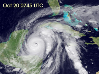 Image
to right: This is an animation that shows Wilma's birth on
October 15 as a tropical depression in the western Caribbean Sea
through Oct. 24, at 8 a.m. EDT when Wilma was battering south
Florida with hurricane force winds. Click on image to view movie
(no audio -- 12.5 Mb). Credit: NASA/NOAA Image
to right: This is an animation that shows Wilma's birth on
October 15 as a tropical depression in the western Caribbean Sea
through Oct. 24, at 8 a.m. EDT when Wilma was battering south
Florida with hurricane force winds. Click on image to view movie
(no audio -- 12.5 Mb). Credit: NASA/NOAA
|
By 7 a.m. EDT Monday, October 24, 2005 Hurricane Wilma’s eye
is expected to make landfall in southwestern Florida.
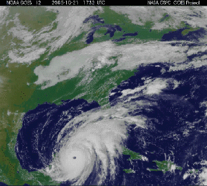 Image/movie to left: This movie from the GOES satellite
shows Hurricane Wilma's movements on October 22, 2005. Click on
image to view movie. Credit: NASA/NOAA
At 11 a.m. EDT Sunday, Oct. 23, Wilma is heading toward Florida in
a northeastward direction over the warm waters of the Gulf of
Mexico. Currently Wilma is a Category 2 hurricane with maximum
sustained winds of 100 mph, and is expected to intensify as she
nears Florida. The center of Hurricane Wilma was located near
latitude 22.7 north, longitude 85.8 west or about 285 mile (460
km) west-southwest of Key West, Florida or about 340 miles (545
km) southwest of the southwestern coast of the Florida peninsula.
Wilma is moving toward the northeast near 8 mph (13 km/hr). A
gradual increase in forward speed and intensity is expected today
or tonight. Estimated minimum central pressure is 961 millibars.
Much to the relief of the Yucatan peninsula of Mexico, hurricane
warnings have finally been discontinued after a harrowing 24 hours
of hurricane force winds and heavy rains, although tropical storm
warnings are still up on the Yucatan’s northeast coast. |
Wilma’s Hurricane Winds Now 24 Hours Over The Yucatan
Peninsula -- 2 p.m. EDT Saturday, October 22, 2005
Hurricane Wilma, now a Category 2 hurricane, packing sustained
winds of 110 mph has brought hurricane winds to the Yucatan
peninsula of Mexico for more than 24 hours and continues to linger
there and move painfully slowly. 24 hours is a long time for those
still in the area to listen to the howling of winds outside, and
for items to tear loose.
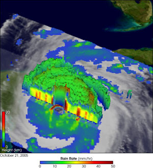 Image to right: Click on image to enlarge. The Tropical
Rainfall Measuring Mission (TRMM) satellite observed Wilma
approaching the Yucatan Peninsula at 8:55 pm EDT October 20, 2005.
This 3-D perspective of Wilma shows a cut away view of the eye
with cloud height on the top right side of the storm and rain
rates in the lower left side of the storm. TRMM reveals that Wilma
has a well-defined, closed inner eye of intense rain surrounded by
larger concentric rings of more moderate rain. The sharply-curved
features in the rain field surrounding the inner eye are the mark
of well-developed, intense circulation. At the time of the image,
Wilma was a Category 4 storm with maximum sustained winds reported
at 150 miles per hour by the National Hurricane Center (NHC).
NASA and NOAA satellites continue to provide the latest data to
forecasters. By 2 pm. EDT on Saturday, October 22, Hurricane
Wilma’s eye was still sitting over land on the Yucatan peninsula
of Mexico, between Cancun and Cozumel. Wilma’s eye is located near
latitude 21.2 north and longitude 87.0 west. That’s about 40 miles
southwest of Key West, Florida. Estimated minimum central pressure
is 953 millibars.
|
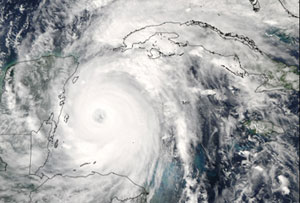 Image
to left: Click on image to enlarge. Hurricane Wilma was a
powerful Category 4 storm when the Moderate Resolution Imaging
Spectroradiometer (MODIS) on NASA’s Aqua satellite took this image
at 2:50 p.m. Eastern Daylight Time, on October 20, 2005. The
previous day, Wilma had surged from tropical storm to category 5
hurricane in record time. Winds around the eyewall of the storm
were raging at 280 kilometers per hour (175 miles per hour).
National Oceanographic and Atmospheric Administration (NOAA)
aircraft had also measured a record-low air pressure of 882
millibars in the center of Hurricane Wilma, making it the most
intense hurricane ever observed in the Atlantic basin. Her place
in the record books firmly established, Wilma backed off this peak
strength somewhat. By the time of this image, she had sustained
winds of 230 kilometers per hour (145 miles per hour). Wilma was
projected to continue into the Gulf of Mexico bringing powerful
winds and heavy rain to both western Cuba and the Yucatan
Peninsula before turning to cross through southern Florida.
Credit: NASA image courtesy Jeff Schmaltz, MODIS Rapid Response
Team, Goddard Space Flight Center Image
to left: Click on image to enlarge. Hurricane Wilma was a
powerful Category 4 storm when the Moderate Resolution Imaging
Spectroradiometer (MODIS) on NASA’s Aqua satellite took this image
at 2:50 p.m. Eastern Daylight Time, on October 20, 2005. The
previous day, Wilma had surged from tropical storm to category 5
hurricane in record time. Winds around the eyewall of the storm
were raging at 280 kilometers per hour (175 miles per hour).
National Oceanographic and Atmospheric Administration (NOAA)
aircraft had also measured a record-low air pressure of 882
millibars in the center of Hurricane Wilma, making it the most
intense hurricane ever observed in the Atlantic basin. Her place
in the record books firmly established, Wilma backed off this peak
strength somewhat. By the time of this image, she had sustained
winds of 230 kilometers per hour (145 miles per hour). Wilma was
projected to continue into the Gulf of Mexico bringing powerful
winds and heavy rain to both western Cuba and the Yucatan
Peninsula before turning to cross through southern Florida.
Credit: NASA image courtesy Jeff Schmaltz, MODIS Rapid Response
Team, Goddard Space Flight Center |
|
|
Source:
http://www.nasa.gov/vision/earth/lookingatearth/h2005_wilma.html
|
Page:
1
2
3
4
5
|
| | |
|


|


|
